Showing posts with label augmented reality. Show all posts

Friday, August 22, 2014

Augmenting History: Riffing on Augmented Reality Pt. 3

...This is a continuation of the 'Augmenting History' posting I stared a few weeks back and is the final entry (3 of 3)

This entry covers some ideas on monetization.

AR Applied to Sporting Events

fenway.jpg
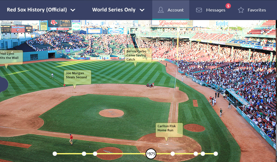
View of the mobile client

While users are waiting for sporting events to begin they could purchase and download official datasets from their favorite teams. They may be able to view the datasets by date or big game.

It would also be possible to ‘Augment stats’- that is, users could advance through the game they are currently watching, inning by inning or quarter by quarter and see the big plays or track trends in where the action is occurring on the field.

Monetization


Generally speaking, the app and tools should be free to help catalyze rapid adoption.

There are a number of angles in which the platform could be monetized including some of the following ideas:

Sponsorship - A session or a dataset would be sponsored by a company for a fee
Paid Premium Content Creation Feature Set - Premium Content Creators (e.g. Official Boston Red Sox) would pay a yearly subscription fee for access to premium features in the content editor. This would make them ‘official’ creators of premium content for the platform. The datasets would look more polished and may be more interactive because of the enhanced feature set they would be using for creation and editing.
Banner Ads - Banner ads would be served in the app - the user could ‘turn them off’ for a small fee
Paid Download of Premium Feature Sets - The ‘Official Gettysburg Data Set from the National Parks Dept. would be available for a small fee.

Note- At first blush the sponsorship model seems the least attractive of these ideas. In order to support the deployment of such a system, alot of support in terms of infrastructure, business relationships and sales would be needed.

Socialization and Datasets


There would be two classes of datasets ‘Free’ and ‘Premium’. Premium datasets are vetted and created by professionals and available for purchase while free datasets can be created by anyone.

Users will have the ability to ‘vote’ and rate data sets (ala Yelp or really any customer review-based app) and filter and search for relevant datasets via their mobile client.

When loading datasets users could filter out lower rated datasets.


Friday, May 9, 2014

Augmenting History: Riffing on Augmented Reality Pt. 2

This is a continuation pf the Augmenting History posting I stared a few weeks back.

This entry adds some more details around how the editing tools could work as well as some more applications of the technology.
Adding Datasets
The Web-Based Editor

User will be able to enter Datasets in to either a web-based or mobile client. These Datasets may be classified as either ‘Free’ or ‘Premium’ with premium sets being made available for a small download fee.

For example, if a user wants to download a premium Dataset such as the ‘Official National Park Dataset’ (vetted and accurate) they will pay $0.99. Alternately, they would also have the flexibility to use an anonymous user’s dataset for free if desired.

All Datasets can have ‘subsets’ which, in concept, act as ‘pages’ of sorts in the parent (main) Dataset container. More details around subsets are included below.


Editing & Creating Data Sets

Users begin by naming their datasets and filling out information about the historical event - an overview of the event (if they desire)

They can then add subsets to their dataset. These are like the pages of a book, each one is independent, but is contained within the parent dataset.

Editing & Creating Data Subsets

Data subsets can be time based, groupings (e.g union, rebel) or general (organized by the user).
Time based subsets will include a playback control on the client when users are viewing these types of datasets. This will allow users to step through/play back time, whether that means advancing through the subsets by minutes, days or years etc.

Subsets that are of the type ‘Grouping’ and ‘General’ don’t have any associated time-based (playback) UI controls, but would be filterable via UI controls like any other subset.

All subsets can be filtered when viewing the data on the mobile client.

Nested subsets (subsets of subsets) will be allowed but only to a level of 1 nesting. For example, ‘day 1 of a battle’ may contain subsets for groups of combatants.

Data Points

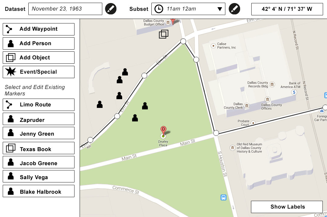
Data points will consist of latitude, longitude and altitude (if input by the user)
Data points are also organized into the following types which will dictate their in-app behavior and the types of data that can be associated with them:

  • Waypoint (path creation)
  • Person (visual distinction)
  • Object (visual distinction)
  • Event (visual distinction)

Augmenting-History-Editor.jpgUsers can add data points based by simply selecting the data point type, clicking on the map and entering some data for the data point. They can also move (edit) data points on the UI by simply clicking and dragging. (Latitude and Longitude appear on the UI and dynamically update as the user moves a datapoint.

Alternately they could also type in GPS coordinates and click add for exact placement.

Note- the mobile editing client would have a ‘live mode’ so users could add data points to their exact/current locations by simply tapping the screen. This way they could walk specific routes in buildings etc and create data.

Concerning altitude, users will also be be able to type in/estimate altitude for a given point. (This would, for example, allow them to properly map a path up a staircase)

IDEA: Specialty objects like ‘ghosts’ may be made available in future iterations for fun events such as ghost tours.

More Examples on the Mobile Client

Aerial Tourism
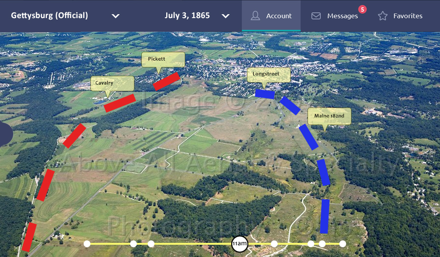
History is often ‘too big’ to be completely experienced by a walking tour. Aerial and skyline tours could include Augmented History to help enhance the user experience.

Gettysburg.jpg

For example, a helicopter tour could actually fly riders along a re-creation of the path John Wilkes Booth used to escape from Washington D.C ir over Day 2 of the Battle of Gettysburg.

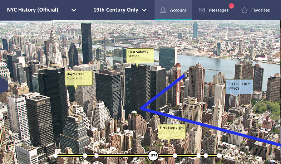
Or maybe they could take a skyline tour of New York City and advance through the years and see how the City evolved over time or where specific historical events happened.

NYC.jpg

Sunday, February 9, 2014

Augmenting History: Riffing on Augmented Reality


A user could stand outside of Ford's theater hold up his phone and see where and how history happened.


I was recently inspired by Tomi Ahonen's presentation on Augmented Reality  that I came across on YouTube:

http://www.youtube.com/watch?v=EvyfHuKZGXU

I thought he made some salient points on AR - how it is the 8th Mass Media and how it may affect our lives in the next 5 to 10 years. It inspired me to start thinking of some of the potential applications of this new and emerging technology and this is one of those ideas.

This will be the first of a 3 part series riffing on AR where I will also explore some ideas on how to monetize it.


Augmenting History


 Want to walk the same path John Wilkes Booth did as he ascended to the Presidential Box in Ford's theater? Or how about stand in the same spot that Abraham Zapruder did on November 22, 1963?

It seems to me we could leverage the emerging AR technology to really make for richer and more immersive tourist interactions at places of historical significance and, to a lesser degree, locations of general interest.

When a user visits a landmark they would have the option of loading a data-set related to the history associated with that area. These data-sets would include the major players that are historically linked to the event or place, how they got there, the paths they walked etc. - as well as plenty of drill-down info to make for a rich, immersive AR experience.

It would take alot of data to prime the pump and get something like this up and running. ALOT of data. So, in order to help achieve a critical mass, in terms of data entry, the paradigm would be broken into two data tiers; Open Source and Premium. The open source data-sets would be contributed by the public and policed and organized by a peer rating system (think yelp/Wikipedia) while the Premium data-sets would be constructed by historians or other professionals and vetted.

Creating the open source data-sets could involve some sort of web-based or mobile client that allows users to enter GPS coordinates and/or even draw paths on the terrain - the way some of these jogging and running sites do.

The User Experience


A user can trace the path of Lincoln or Booth through Ford's theater


The user would visit a landmark or historical area and use their mobile device to view the additional historical data. They would also have the ability to load the data-set they desired and filter different data depending on what they wanted to see on their screen.

A user scans Dealey Plaza with their mobile device using the November 22, 1963 dataset.
It is plausible that there may be hundreds of data-sets for the more popular tourist attractions and users will have the ability to sort through what is available based on a data-set's rating or they may opt for the higher quality, more comprehensive premium data-set.

Part 1 of 3, to be continued...